UAS types
INTERSPECT UAS B1.1
for Photogrammetric and Geodetic surveys
INTERSPECT UAS B2.2
for quick surveys
INTERSPECT UAS B3.1
3D vegetation surveys
INTERSPECT UAS B4.1
Dense 3D surveys
for Photogrammetric and Geodetic surveys
for quick surveys
3D vegetation surveys
Dense 3D surveys
- Aerial mapping of plant health, some key soil parameters, water shortage capabilities and inland water
- Defining management zones for precision agriculture
- Mapping for the precise dosing of nutrients and chemicals
- Mapping of resources and amounts
- Monitoring
- Detecting the conditions
- Maps and databases for impact assessments
- Vegetation mapping
- Forest management
- Forest damage mapping
- Localization of infections and insect pests
- Surveys for national parks and conservation areas
- Mapping the invasive plant species
- 3D City
- Ortho image maps of city GIS
- Change monitoring
- Dense 3D point cloud of the surface and the objects
- 3D documentation of monuments
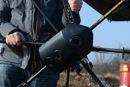
- Single DSLR camera
- Calibrated 25 MP frame camera for photogrammetry
- Traditional mapping tasks
- Two-axis camera holder with servo motor
- Mission Planner
- Coming home function
- Failsafe
- Tracking System
- GPS
- Barometric altimeter
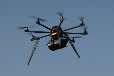
- Operating time with maximum load: 15 min
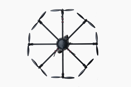
- Dimensions: 364 x 960 x 960 mm
(D max = 1165 mm)
- Weight: 5,2 kg
- PhotoScan Pro software
- No direct orientation
- INTERSPECT NDVI or RGB camera
- Calibrated single frame camera for quick photogrammetry
- For mapping wetlands, marshes, inaccessible places
- Two-axis camera holder with servo motor
- Mission Planner
- Coming home function
- Failsafe
- Tracking System
- Direct orientation
- Barometric altimeter
- Operating time with maximum load: 15 min
- Dimensions: 364 x 960 x 960 mm
(D max = 1165 mm)
- Weight: 5,2 kg
- PhotoScan Pro software
- INTERSPECT Forest Survey Camera (Complex MS - 3D system)
- 3D vegetation survey
- NDVI, Vi Green maps with corrections in the imaging system & dense 3D pointcloud
- Mission Planner
- Coming home function
- Failsafe
- Tracking System
- GPS
- Barometric altimeter
- Operating time with maximum load: 12 min
- Dimensions: 364 x 960 x 960 mm
(D max = 1165 mm)
- Weight: 5,5 kg
- PhotoScan Pro software
- INTERSPECT 3D Mapping Camera System
- Pentacamera & 3D measurement technology
- 3D City, Dense 3D point cloud of the surface and the objects
- Mission Planner
- Coming home function
- Failsafe
- Tracking System
- GPS
- Barometric altimeter
- Operating time with maximum load: 12 min
- Dimensions: 364 x 960 x 960 mm
(D max = 1165 mm)
- Weight: 5,6 kg
- PhotoScan Pro software
- Stability and high wind tolerance
- High payload capacity
- Safe
- Spectral sensitivity adapted to the needs
- High resolution
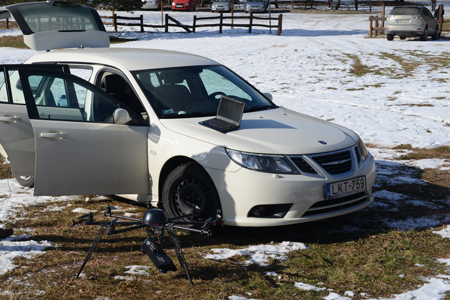
- Remote Controller (G-MX20 12 channel, 2.4 GHz)
- Battery set
- Transport box
- Spare parts: Two pairs of carbon propeller (right / left)
- Tracking System
- Mission Planner
- Photogrammetric software